Telegraph lines in the Goldfields Region: Overview.
- Australia 1901-1988
- New South Wales
- Overview of NSW
- Telegraph lines
- Telegraph Offices
- Date stamps
- Forms
- Envelopes
- Instructional annotation
- Collect
- Delayed
- Free
- Immediate Urgent
- Reply paid
- Rates
- Stamps
- 1871 Telegraph stamps
- 1885 proposal
- 1893 proposal
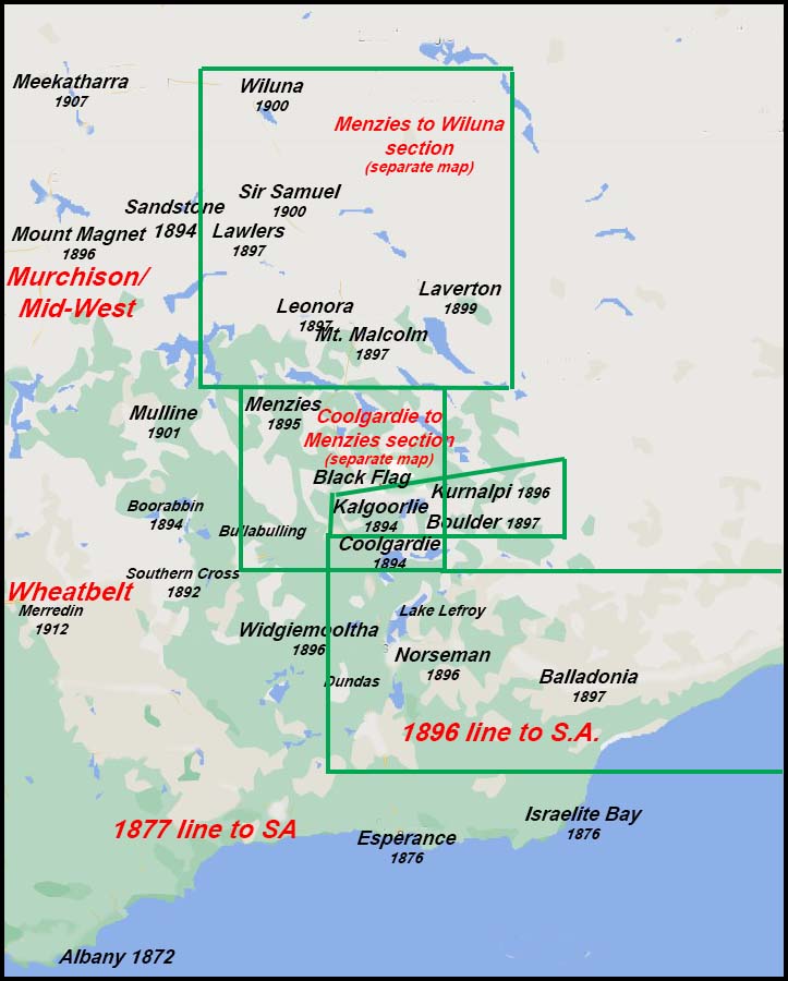
The Goldfields Region is defined, for the purposes of describing the construction of telegraph lines to the Goldfields in the Eastern area of Western Australia, as extending:
- from the junction of the Mid West and Wheatbelt regions east of Southern Cross;
- to the east of the Southern region;
- from Coolgardie through Menzies to west of Wiluna in the north;
- beyond Boulder to Kanalpi and east to the South Australian border;
- from Ravensthorpe in the south through Dundas, Norseman and Esperance to Eucla on the South Australian border.
The small map below represents an area of about 955,000 km2 - bigger than Texas (676,000 km2) and nearly four times the size of the U.K. (242,000 km2).
If Western Australia were a country, it would be ranked 30 in terms of size.
 |
|
The boxes shown on the map are detailed areas of the Goldfields region which are elaborated below.
Traces of gold had been found in Western Australia since at least the early 1850s. None showed significant results (that we know of). Robert Austin, a Government Surveyor, found good traces of gold in the Murchison in the 1850s but his reports were buried in the files - the Government did not want a gold rush which would take workers away from the newly established outposts of Perth and Albany.
The first discoveries of gold in the Yilgarn region had occurred in 1887 and rushes in the Southern Cross region occurred later in that same year. Again nothing much happened (that we now know about). Subsequently gold rushes started:
- at Coolgardie in 1892 after initial reports from Arthur Bailey and William Ford; and
- at Kalgoorlie in 1893 after reports from Patrick "Paddy" Hannan, Tom Flanagan and Dan Shea.
For an excellent review of the history of the gold rush 1893-1897, see the Chapter by Warren Bert Kimberly and also the WA Now and Then website. The importance of the gold discoveries for the current discussion is that the discoveries brought so many people and support mechanisms (Wardens, hospitals, police, etc) that rapid communication became an absolute necessity - and one which had to be met in the shortest possible time.
York was the Telegraph Office in the west from which the line extensions into this region were developed.